
This past weekend when Patti and I drove to Virginia we passed a sign noting we were crossing the Mason-Dixon Line. Patti asked me how it got the name and wondered if it was named after someone related to the Civil War. She had always heard the term when people spoke about the North and South and free and slave states, so her assumptions were logical.
But as I shared with her yet another one of “Steve’s stories,” it hit me this might be an interesting Blog.
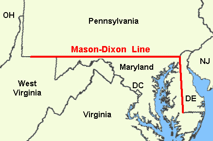
Where is the Mason-Dixon Line? The Mason-Dixon Line is the wonderfully straight east-west border line between Pennsylvania and Maryland/West Virginia and the north-south border line between Maryland and Delaware. (See map.)
Charles Mason and Jeremiah Dixon. The line is named after the two British men who surveyed the line over four years between 1763 and 1767. Mason was a well-known astronomer and Dixon was an especially skilled surveyor. As you can read in Bill Bryson’s book A Short History of Nearly Everything, they had previously gained fame working on scientific projects around the world wrestling with how large the Earth was and how much mass it had.
Why They Did the Survey. The survey was done to settle a border dispute between William Penn and his Pennsylvania Colony and the Calvert family and their Maryland Colony. If you read details about the disputes in the early 1700’s it reminds me of a civilized Hatfield and McCoy battle. Anyways, to make a long story short, a British judge ordered the survey to settle the dispute. The families chose Mason and Dixon because of their fame and skill and ability to work in difficult and challenging geographical conditions.
The Survey. One of the reasons there was a dispute was that when the King gave Maryland their grant it covered an area of land from the Potomac River north to the 40th parallel, which turns out is north of Philadelphia, a town William Penn had already settled. So among the agreed upon challenges the surveyors worked with was finding a new point to start the line that was 15 miles south of the most southern house in Philadelphia.
In any case, it took Mason and Dixon four years to finish first the north-south line between Delaware and Maryland and then the east-west line between Maryland and then Virginia (later in 1865 West Virginia). The biggest challenge they faced was dealing with Native Americans, so they hired Iroquois guides to help them. They actually had to stop at Dunkard Creek about 30 miles short of their western goal because their Iroquois guide would not go into enemy Lenape territory. That stretch of the line would not be finished until new surveyors, Rittenhouse and Ellicott, could finish in 1784.

Mason and Dixon marked every mile along the way with special stones from England. And, every five miles, they placed a “crownstone” monument like the one in this picture. On the south side of the marker is the Calvert family coat of arms and on the north side is the Penn family coat of arms. Apparently many of these monuments still exist and are protected by cages.
Several scientific advancements were learned during this survey that contributed to our understanding of the earth’s mass and the calculations of longitude.
The North and the South. Later on in the 1820’s the Mason-Dixon Line between Pennsylvania and Maryland became more famous as it was also used to separate free states and slave states. The line was specifically used as part of the Missouri Compromise and became part of what then became known as the “Missouri Compromise” line. If you remember, this Compromise was developed in Congress to make sure that as states were admitted to the Union there continued to be an equal balance of free and slave states.
I hope you enjoyed this little variance from my normal Blogs and trust you will now be able to tell people all about the Mason-Dixon line when it next (or never) comes up in conversations among your friends!
